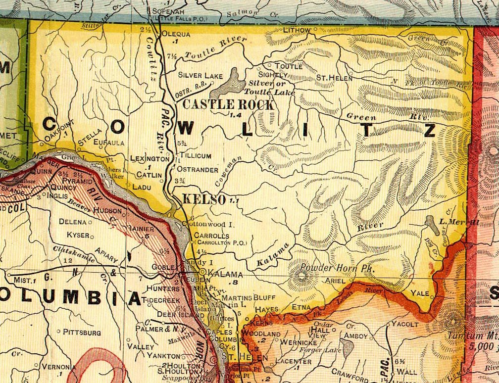
Ariel
Ariel is located 10 miles east of Woodland on State Route 503, at the west end of Lake Merwin. The original town site was 17 miles up the Lewis River from Woodland, but was moved in 1929 when the creation of Merwin Dam flooded the townsite. The post office was established in 1899 by Leander M. Chitty and named for his son, Ariel. In the 1940 census, residents of Ariel were enumerated in Reno Precinct.
Ariel Links:
- 1940 Census Index, Reno Precinct
- See the entry for Ariel in Robert A. Reid's 1912 book, "Puget Sound and Western Washington."
- See the entry for Ariel in the "Oregon, Washington and Alaska Gazetteer and Business Directory, 1901-1902"
- "Water Babies" - Margaret Hepola's history of the North Fork valley of the Lewis River before it was flooded by the creation of the Merwin Dam.
Arkansaw
Also spelled Arkansas. The following account was originally published in the "Cowlitz County Advocate" (Castle Rock, WA) in 1895, and reprinted in the Advocate on Thurs., July 26, 1951 (Vol. 65, No. 12, 65th Anniversary Edition):
"Arkansaw Prosperous Farm Community; Has Post Office in '95""This prosperous community is provided with a postoffice, Jackson, where they receive mail daily except Sunday. The postmaster is J. K. Conger, who also runs a well appointed general merchandise store. In the Arkansaw valley are located some of the best improved farms in the county and it is one of the most prosperous communities of the county.
"This valley is noted for its rich agricultureal [sic] lands and fine timber - cedar, fir and other varieties. Here are also found some of the most extensive orchards of the county.
"Among the prosperous citizens who have well improved farms are: Mrs. Mary Jackson, the Elisha Jackson homestead, William Whittle Sr., Ira C. Conger, J. K. Conger, A. H. Helms, Charles Tabaka, W. L. Lank, Jerome Johnson, Rev. Bailes, J. D. Wright, A. Johnson, Fred and W. H. Leonard, W. H. Douglas, Lobistine, Matt Duffy, J. T. McMillan, Mr. Crawford, Mr. Petigo, J. H. Meyers, J. M. Carnine, Nelson Huntington, Robert Jackson, A. Wehmeyer, N. J. Carson and the Baxter place.
"These citizens with barely an exception have comfortable homes, good orchards and plenty of stock, cows, horses, hogs, etc."
Arkansaw Links:
- 1940 Census Index, Arkansas Precinct
- For more information, see Meany's "Origin of Washington Place Names".
- See the entry for Arkansaw in the "Oregon, Washington and Alaska Gazetteer and Business Directory, 1901-1902"
Brinion Mountain
Election precinct in 1940 census.
Burke Island
For more information, see the listing for Burke Island in Meany's "Origin of Washington Place Names".
Butte Hill
Butte hill was a Finnish settlement near Woodland in southwest Cowlitz County, named for Butte, Montana, where many of the settlers came from. The area was settled during World War I.
Caples
Caples was located on the Columbia River 3 miles west of Woodland. The town was named for Hezekiah Caples, the first postmaster. The post office was established by Joseph Wright, a store owner, and operated from 1890 to 1909 (Ramsey, p. 190-91). See also Caples Landing.
Caples Links:
- 1940 Census Index, Caples Precinct
- See the entry for Caples in the "Oregon, Washington and Alaska Gazetteer and Business Directory, 1901-1902"
Caples Landing
Caples Landing was located a mile from the Caples Post Office, on the east bank of the Columbia River, and was also named for Hezekiah and Jane Caples, who owned a homestead nearby. Hezekiah's brother John was postmaster at Pekin. Hezekiah's father, Joseph, settled in the area in 1844. A steamboat landing was built here, and even after the landing was no longer used, this area was called Caples Landing (Ramsey, p. 190-1).
Carrolls
Carrolls is located 3 miles south of Kelso off of Interstate-5. It was originally named Carrollton in 1871 when the post office was established. Its namesake, William and Catharine Carroll, owned and platted the property the post office was built upon. In 1915, the name was changed to Carrolls and the town was built around the station built by the Northern Pacific Railway Company (Ramsey).
"The present town of Carrolls on the Columbia was originally platted in 1871 by Major Carroll and his wife. It was called Carolton in the first plat and Carrolton in the second one. Its first actual settler was a Dane, named Neils Anderson, who took up a donation land claim there in 1854. It was finally platted for a third time in 1910, under the name of Carrollton. The name was changed to Carrolls on March 17, 1915" (Cowlitz County Inventory, pp. 13-14).
Carrolls Links:
- 1940 Census Index, Carrolls Precinct
- For more information, see the listing for Carrolls in Meany's "Origin of Washington Place Names".
- See the entry for Carrolls in the "Oregon, Washington and Alaska Gazetteer and Business Directory, 1901-1902"
- See the entry for Carrollton in the "Oregon, Washington and Alaska Gazetteer and Business Directory, 1901-1902"
- See the entry for Carrolton in Robert A. Reid's 1912 book, "Puget Sound and Western Washington."
Carrollton
See under Carrolls.
Castle Rock
(2000 population: 2,130). Castle Rock is located on the east bank of the Cowlitz River, 7 miles south of the Lewis-Cowlitz county line on State Route 411. William Huntington, a cousin of Harry Darby Huntington (see Monticello), named the area in 1853 for a large 150-foot high rock south of the town. In 1854, Huntington established the first post office, and in 1889 he and his wife, Eliza Jane (Koontz) Huntington, platted the town. From 1859-1872, the post office operated out of the home of Henry Jackson (Ramsey, p. 159-62; William Huntington Biography).
Castle Rock Links:
- 1930 Census - Castle Rock Town (North Part) - transcribed by Janice C. Buker
- 1940 Census Index, Castle Rock, North Precinct
- 1940 Census Index, Castle Rock, South Precinct
- City of Castle Rock - official website
- A detailed history of the Castle Rock Area was written by Bud May and posted on the "Washington History" website (a project of the Secretary of State's office).
- For more information, see the listing for Castle Rock in Meany's "Origin of Washington Place Names".
- See the entry for Castle Rock in the "Oregon, Washington and Alaska Gazetteer and Business Directory, 1901-1902"
- See the entry for Castle Rock in Robert A. Reid's 1912 book, "Puget Sound and Western Washington."
- Hubbard Cemetery (part of Interment.net Cemetery Transcription Library)
- IOOF Cemetery, Castle Rock (part of Interment.net Cemetery Transcription Library)
- Jackson Cemetery (part of USGenWeb's Tombstone Transcription Project)
- Jackson Cemetery (part of Interment.net Cemetery Transcription Library)
- Meadowview Cemetery (part of Interment.net Cemetery Transcription Library)
- Smith-Tucker Cemetery (part of Interment.net Cemetery Transcription Library)
- Tower Cemetery (aka Rosin Cemetery and St. Paul Lutheran Church Cemetery) (part of Interment.net Cemetery Transcription Library)
- Tower Township Cemetery (part of Interment.net Cemetery Transcription Library)
- Whittle Cemetery (part of Interment.net Cemetery Transcription Library)
- Castle Rock Visitor's Center
- St. Matthew Episcopal Church
- Mt. St. Helens Communities - Castle Rock - by Cowlitz County Tourism
Catlin
Catlin was located within present-day West Kelso. It was largely a continuation of Freeport. It was located on the Donation Land Claim of Seth and Mary Catlin, which they settled in the 1860s. The town was established in 1889 as Marysville. "What is now West Kelso began with the sale of town lots in 1889 in a tract of land then called Marysville. This tract belonged to Adam and Mary Catlin. On petition of its citizens the name of Marysville was changed to Catlin in 1892, in honor of the family upon whose land claim the settlement was established. Following approval of the voters at an election held in March 1908, Catlin was annexed to Kelso and has since been known as West Kelso" (Cowlitz County Inventory, p. 14). Orin Hinson established the post office, which operated from 1892 to 1909 (Ramsey, p. 193-4).
Catlin Links:
- For more information, see the listing for Catlin in Meany's "Origin of Washington Place Names".
- See the entry for Catlin in the "Oregon, Washington and Alaska Gazetteer and Business Directory, 1901-1902"
- See the entry for Catlin in Robert A. Reid's 1912 book, "Puget Sound and Western Washington."
Chestnut
A post office was established here on June 14, 1902 by Orlen A. Lewis, but rescinded October 27, 1902. "The record would indicate that, if the office ever operated it was for only a short time. Its location has not been determined." (Ramsey, p. 204)
Coal Creek
Coal Creek was established as a logging camp in the early 1900s. Present-day Coal Creek precinct is located west of Longview, and east of Stella. In the 1940 census, some Coal Creek residents were enumerated along Ohio Street and 46th Ave, placing its extent into present-day West Longview. Coal Creek school operated in the early 1910s, and was also the site of Coal Creek Church (which celebrated its 100th anniversary in 2012).
Coal Creek Links:
- 1940 Census Index, Coal Creek Precinct
- Coal Creek Church set to celebrate some important milestones - article by Natalie St. John in The Daily News of Longview, 6 Apr 2012.
Cloverdale
A precinct in the 1930 and 1940 Cowlitz County censuses, located within present-day Kalama. The Cloverdale School District No. 22 operated in the 1930s.
Cloverdale Links:
Columbia Heights
Columbia Heights was settled in 1902 by twelve families from Puolanka Olilum Laani, Finland. The settlement was orginally called Puolongan Hill (Ott and York, p. 127).
Cottonwood Island
Cottonwood Island is located near Longview-Kelso (Section 24, T7N - R2W). Alfred E. Houchens established a donation land claim here on Jan. 21, 1887, but sold it to L. P. Smith (and his wife, Ruhannah) on December 30, 1885 for $1500. Following the Smith's divorce, the property was sold in 1895 to Ed and Nancy Metcalf and Joseph and Lucinda Gross. They in turn sold the property to Charles H. Thwing for $1000 in 1898. The Thwings established a seining ground here until they sold the property to their eldest daughter, Laura and her husband, Roger Risley in 1906 (for $10,000). Roland Brusco, Sr. bought the island from the Risleys in 1968 (for $160,000) and he in turn sold the island to the Cottonwood Island Association of Seattle for $5,000,000 in 1982 (Ott and York, p. 130).
Cottonwood Island Links:
- For more information, see the listing for Cottonwood Island in Meany's "Origin of Washington Place Names".
Cougar
Cougar is located 24 miles northeast of Woodland, at the eastern end of Yale Lake near the Cowlitz-Skamania county border. The post office was established in 1901 by Amanda (Beavers) Robbins, wife of William J. Robbins (Ramsey, p. 203). In May, 1980, the entire town was evacuated after the eruption of Mt. St. Helens. Cougar is a popular tourist spot as it is the southwestern gateway into Mt. St. Helens Volcanic Monument. Pamela Gibson Barlow adds that "My family is from Cougar, Washington and Woodland. They have been there many years in fact a lot of them have passed away. I am very surprised to not find them listed in a lot of sites pertaining to this area as they owned most of the town of Cougar for many years. The names were Ben & Ethel Robbins, Ethel was one of the first postmasters there and later her daughter Alice Thomas was for years. Al & Alice also owned one of the stores in Cougar. The other side of my family the Wilkinson also owned a store in Cougar for years. My Great grandparents home was a land mark known to many."
Cougar Links:
- For more information, see the listing for Cougar in Meany's "Origin of Washington Place Names".
- Mt. St. Helens Communities - Cougar - by Cowlitz County Tourism
Cougar Flat
Cougar Flat was an enumeration district in the 1910-1940 censuses; unincorporated portions of Ryderwood were part of this precinct. I have no further information on the location of this precinct.
Cougar Flat Links:
- 1910 Census, Cougar Flat Precinct
- 1930 Census, Cougar Flat Precinct
- 1940 Census Index, Cougar Flat Precinct
Coweeman
The site of Coweeman was unknown, but was probably located near Kelso. A post office operated here from 1877 to 1882, with Martin Larsen as postmaster (Ramsey, p. 175).
Coweeman Links:
- For more information, see the listing for Coweeman in Meany's "Origin of Washington Place Names".
Cowlitz Prairie
"A landing on the Columbia river, in Cowlitz county, 50 miles below Portland, Or." (source: "Oregon, Washington and Alaska Gazetteer and Business Directory, 1901-1902").
Davenport
Davenport was located at the present site of Kalama, and was presumably the precursor to Kalama. Smith M. Hensill established the post office which operated here from Aug., 1867 to Jan., 1868 (Ramsey, p. 162).
Delameter Valley
Located near Castle Rock. Also known as Scanty Grease. Delameter Valley was named for its oldest citizen, Dan Delameter, who was born in the area. A grist mill was built on Delameter Creek in 1872 (Ott and York, p. 128). The following account was published in the "Cowlitz County Advocate" (Castle Rock, WA) on Thurs., July 26, 1951 (Vol. 65, No. 12, 65th Anniversary Edition):
"How Scanty Grease (Now Delameter Valley) Was Named"
"How did the pleasant little community now known as Delameter Valley become known to the early residents as Scanty Grease?
"According to Chancey Davis, old-time settler in the district, Willard Johnson was hunting cattle one day and happened in on a family in the valley. He was there are meal time and partook of flapjacks and barley coffee. The lady greased the griddle with a rutabaga. Mr. Johnson's remark was, 'Scant of grease?' and the name stuck."
Elk Creek
Elk Creek was located 10 miles southeast of Saint Helens on the Toutle River. Mrs. Pearl Gould, wife of James Gould, established the post office in 1912. The post office was discontinued in 1913 (Ramsey, p. 204).
Eufaula
Eufaula was located 4 miles northwest of Longview and two miles north of the Columbia River. Benjamin Franklin Brock, a native of South Newbury, Vermont and owner of B. F. Brock Logging Company, established the logging town. Jefferson P. Buford named the town for his home in Alabama. The company store was also the site of the post office, which operated from 1895 to 1912 (Ramsey, p. 197).
Eufaula Links:
- See the entry for Eufala in the "Oregon, Washington and Alaska Gazetteer and Business Directory, 1901-1902"
- The Eufaula Company - series of photos from 1921 documenting The Eufaula Company's logging operation. Part of the University of Washington Digital Collection.
Fisher Island
Located in the Columbia River, in southern Cowlitz Co. Described in Meany's "Origin of Washington Place Names".
Freeport
Freeport was located within the current city limits of Longview, 2.5 miles from the mouth of the Cowlitz River. Nathaniel Stone platted the town in 1866, naming it for his hometown of Freeport, Indiana. From 1865 to 1884 it was the main commercial town on the Cowlitz River (Summers, p. 230). In 1866, Charles Forsythe built and taught in Freeport's first school, which was also only the second school built in the county. The schoolhouse was torn down in 1939 (Summers, p. 230-31). On November 13, 1865, voters elected to move the county seat from Monticello to Freeport as Nathaniel Stone could gaurentee meeting space in his warehouse. Freeport remained county seat until 1872, when it was moved to Kalama (Summers, p. 237). Charles Catlin, a son-in-law of Nathanial and Eliza Ostrander, established the post office in 1867. The post office was discontinued in 1893, and the town largely abandoned when many of its structures and businesses were incorporated into Kelso (Ramsey, p. 163-5). The townsite continued on as Catlin.
Freeport Links:
- For more information, see the listing for Freeport in Meany's "Origin of Washington Place Names".
- See the entry for Freeport in the "Oregon, Washington and Alaska Gazetteer and Business Directory, 1901-1902"
- Freeport, 1873 - photo from the University of Washington's Digital Collection
Gardner
Gardner was an old settlement on the north bank of the Toutle River, at the Cowlitz River junction (2.5 miles north of Castle Rock). It was named for James Gardiner, who arrived in the area in July, 1852. His sons, James A. and William A., inherited the property upon his death in 1858.
Gardner Links:
- For more information, see the listing for Gardner in Meany's "Origin of Washington Place Names".
German Creek
German Creek was the name of a creek and a settlement about 12 miles from Longview. Many families of German descent settled in this area in the 1870s.
Goble Creek
See under Rose Valley.
Green River
See under Lithow.
Greenwood
Formed in 1922 from parts of Lancaster, North Kalama and Pigeon Springs precincts (source: "Fifteenth Census of the United States: 1930. Population", Bureau of the Census). Located east of Kalama along Kalama River Road.
Greenwood Links:
Hayes
This town is not listed in Guy Ramsey's book, but does appear on a Cram's 1909 map of Cowlitz County. It is located between Kerns and Etna on the Cowlitz-Clark County border.
Jackson
Jackson was located on Henry Jackson's homestead, about 1.5 miles southwest of Castle Rock on the Arkansaw Creek. The Castle Rock post office operated out of the Jackson home from 1859 to 1872. The home, built in 1860 and later converted to an inn, was considered the oldest home in the county built from milled lumber. William M. Jackson established a post office in Jackson in 1883, which continued until 1902 (Ramsey, p. 181-2).
Jackson Links:
- For more information, see the listing for Jackson in Meany's "Origin of Washington Place Names".
- See the entry for Jackson in the "Oregon, Washington and Alaska Gazetteer and Business Directory, 1901-1902"
Jimtown
Jimtown, located near Castle Rock, was named for Jim Studebaker, a local settler.
Kalama
(2000 population: 1,783) Kalama is located 11 miles south of Kelso, between the Columbia River and Interstate-5. Kalama began as Davenport. General John W. Sprague renamed the town in 1871 from the Indian word "Calama," meaning "pretty lady." The Northern Pacific Railway Company built a railroad from Kalama to Tacoma, thus making Kalama an important transportation center. As a result, voters moved the county seat from Freeport to Kalama in 1872, where it remained until 1922. Kazana House became the county courthouse (Summers, p. 242-44). Most of the business district was destroyed by fire in 1879. From 1884 to 1903, the ferry TACOMA ferried passengers across the Columbia River from Goble, Oregon to Kalama. The first postmaster was Ila S. Bennett, who established the post office in 1868 (Ramsey, p. 167-9).
Kalama Links:
- 1880 Census, Kalama Precinct
- 1940 Census Index, Kalama - Columbia Precinct
- 1940 Census Index, Kalama - North Precinct
- 1940 Census Index, Kalama - South Precinct
- For more information, see the listing for Kalama in Meany's "Origin of Washington Place Names".
- See the entry for Kalama in the "Oregon, Washington and Alaska Gazetteer and Business Directory, 1901-1902"
- See the entry for Kalama in Robert A. Reid's 1912 book, "Puget Sound and Western Washington."
- Port of Kalama
- The City of Kalama has posted a different account of how Kalama got its name.
- Kalama School District
- Mt. St. Helens Communities - Kalama - by Cowlitz County Tourism
Kelso
(2000 population: 11,895) Kelso, the Cowlitz County seat and second-largest city in the county, is located along Interstate-5 two miles northeast of Longview. Kelso is divided into Kelso and West Kelso by the Cowlitz River. The site of Kelso was part of Peter Crawford's donation land claim, which he obtained in 1847. After Crawford's family moved to Vancouver, Crawford decided to establish a town on his homestead. On October 2, 1884, he filed a plat for the townsite, reserving one block of land for the future Cowlitz County courthouse. He began to sell lots in 1885, the first buyer being A. H. Edlin. Edlin built a home and store, and contracted for the post office (Summers, p. 263-70). Franz H. Kleber established the post office here in 1886 (Ramsey, p. 188-89). In the fall of 1887, the first school in Kelso was held in the old Crawford home, taught by Rose Brooks. In 1889, Kelso had 500 residents and a new schoolhouse with 44 students (Summers, p. 70-73). Kelso was incorporated on January 7, 1889 (Summers, p. 285). Peter Crawford died seven months later, on June 10, 1889, at age 70 (Summers, p. 293). Although he set aside land in anticipation of the county seat moving to Kelso, this did not happen until 1922 (Summers, p. 294).
Kelso Links:
- 1940 Census Index, Catlin Precinct of Kelso City
- For more information, see the listing for Kelso in Meany's "Origin of Washington Place Names".
- See the entry for Kelso in the "Oregon, Washington and Alaska Gazetteer and Business Directory, 1901-1902"
- See the entry for Kelso in Robert A. Reid's 1912 book, "Puget Sound and Western Washington."
- Kelso City Government
- Kelso School District
- 1925 Kelso High School "Tamahnawus" Yearbook - index to names in the yearbook.
- Lyn Topinka has a great collection of photos and history of Longview and Kelso as part of her "Columbia River Images" website.
- Kelso-Longview, Washington - nice collection of photos and history of locations of note in Kelso and Longview, written and maintained by Robert D. West.
- Ostrander and Kelso Mystery People - photos of friends and neighbors of the STOVER family of Ostrander. Includes photos of three unknown students at Kelso High School (1922). Can you identify any of these people?
- "GenDisasters: Kelso, WA Cowlitz River Bridge Collapse, Jan 1923" (Internet Archive link)
- Seattle Now & Then: Kelso's Allen Street drawbridge, 1909 - another account of the Cowlitz River Bridge Collapse, written by Clay Eals (May 2024).
- Mt. St. Helens Communities - Kelso - by Cowlitz County Tourism
- Cemetery commissioners hope historic recognition reroutes gas pipeline - describes efforts of Cowlitz Co. Cemetery District No. 6 commissioners to prevent a natural gas pipeline from passing through land owned by Mount Pleasant Cemetery.
Kerns
Kerns was originally Woodland. In October, 1890, Adolphus Lee Lewes moved the post office to his home one mile north of Woodland and renamed it Kerns. Christopher Bozarth, the original postmaster of the Woodland post office, reestablished another post office by the name of Woodland in November, 1890. Lewes continued the Kerns post office until 1906 (Ramsey, 191-2).
Kerns Links:
- See the entry for Kerns in the "Oregon, Washington and Alaska Gazetteer and Business Directory, 1901-1902"
Kid Valley
See under Lithow.
LaDu
This town was located on the north bank of the Columbia River, within the current southwestern city limits of Longview. Crumline La Du (born Nov. 1, 1808 in New York), settled on his donation land claim here in 1850. When he established the first post office here in 1872, the town was named Mount Coffin. Crumline had only one son, James La Du, who never married. In order to preserve the family name, James renamed the town LaDu in 1895. The post office was discontinued in 1913 (Ramsey, p. 169-71, 196).
Ladu Links:
- See the entry for Ladu in the "Oregon, Washington and Alaska Gazetteer and Business Directory, 1901-1902"
- 1930 Census, LaDu precinct
Lake Merrill:
The small community of Lake Merrill was located near the lake of the same name, at the headwaters of the Lewis River in southeast Cowlitz Co., near the town of Cougar. According to Edmund Meany's "Origin of Washington Place Names", it was named by James McBride and Frank Vandever for McBride's father-in-law. Amanda Robbins, postmistress of the Cougar Post Office, was a resident of Lake Merrill. The lake itself is a popular spot for fly-fishing.Lake Merrill Links:
- 1920 Census, Lake Merrill precinct
- 1930 Census, Lake Merrill precinct
- Merrill Lake - brief description on recreation at Merrill Lake, with photos.
Lancaster
Lancaster was a precinct in the 1880 census. Lancaster became Woodland in 1881.
Lancaster Links:
Lexington
The community of Lexington is located about 7 miles south of Castle Rock on State Route 411. Mrs. Jesse I. Hammond founded a post office here in 1888, which was discontinued in 1917 (Ramsey, p. 190).
Lexington Links:
- See the entry for Lexington in the "Oregon, Washington and Alaska Gazetteer and Business Directory, 1901-1902"
- See the entry for Lexington in Robert A. Reid's 1912 book, "Puget Sound and Western Washington."
Lithow
Lithow was located in the Green River District about 4.5 miles west of Saint Helens. It was originally named Kid Valley. In 1922, Kid Valley was annexed to Green River precinct (source: "Fifteenth Census of the United States: 1930. Population", Bureau of the Census). Thomas B. Madden established the post office here in 1900, which continued until 1911 (Ramsey, p. 201).
Lithow Links:
- See the entry for Lithow in the "Oregon, Washington and Alaska Gazetteer and Business Directory, 1901-1902"
- 1910 Census, Kid Valley Precinct
- 1930 Census, Green River Precinct
Little Kalama
Election precinct in 1940 census.
Little Kalama Links:
Longview
(2000 population: 34,660) Longview, the largest city in Cowlitz County, is located 2.5 miles southeast of Kelso. It was the first planned city in the Pacific Northwest. Planned and built in the 1920s, it was named for its founder R. A. Long, of the Long-Bell Lumber Company.
Longview Links:
- 1930 Census, Monticello precinct
- Were you a patient at St. John's Hospital, Cowlitz General, or Monticello Medical, all in Longview? Did you know you can obtain copies of your records? To learn more, go HERE.
- City of Longview
- Kelso-Longview, Washington - Robert D. West's website that offers a thorough and detailed look at the history of Kelso and Longview, particularly of the interesting and historical locations within these cities. [The original link is no longer working; this link points to a version archived on Internet Archive - most of the content will load, but some photos are missing.]
- Lyn Topinka has a great collection of photos and history of Longview and Kelso as part of her "Columbia River Images" website.
- Kelso-Longview, Washington - nice collection of photos and history of locations of note in Kelso and Longview, written and maintained by Robert D. West.
- View early photos of the Columbia River Longview Bridge
- View early photos of Longview points of interest
- "Columbia Theater in Longview opens on April 4, 1925" - an article written by Eric L. Flom for HistoryLink.org, describing the oldest theater in Longview.
- The Daily News
- Longview School District
- View photos from the R. A. Long High School yearbook (1941)
- Booth-Whitney families of Longview - many photos of the Booth and Whitney families, as well as other people and places in and around Longview, contributed by Nancy Hicks.
- St. Stephen Episcopal Church
- Mt. St. Helens Communities - Longview - by Cowlitz County Tourism
Lower Cowlitz
Lower Cowlitz was a settlement on the east bank of the Cowlitz River, about five miles south of Castle Rock. Edward Fallieu was the only postmaster during the post office's brief existence, from Feb., 1873 to Oct., 1874 (Ramsey, p. 171).