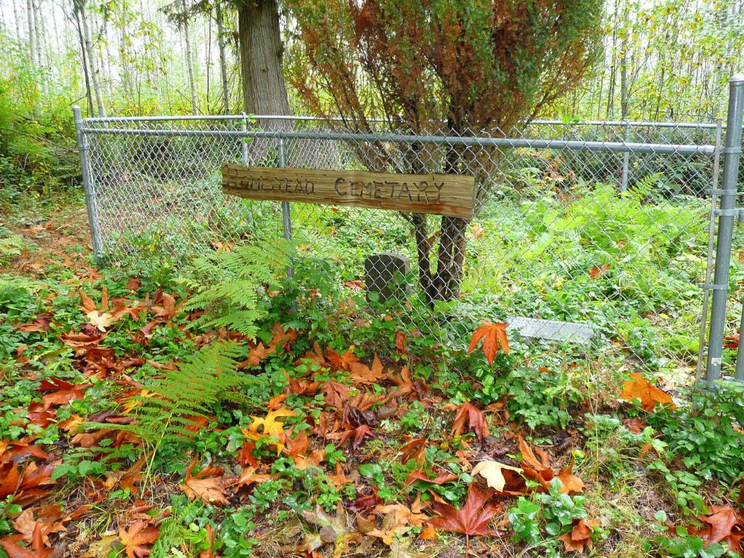
The "Homestead Cemetery," in what was once Windom, contains only two graves, for cousins Sarah Marinth Withrow and Mira Cordelia McKinna. Perry Brake photographed these stones, and contributed information on the location of the cemetery, as well as the Withrow family. Perry is not related to either girls, but says, "I hope it will provide a piece for somebody's family history puzzle."
(Click on image to view larger photo)
 |
 |
| (Click on image to view larger photo)
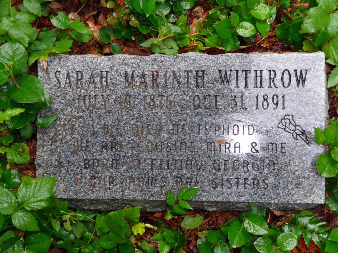
"Sarah Marinth Withrow |
(Click on image to view larger photo)
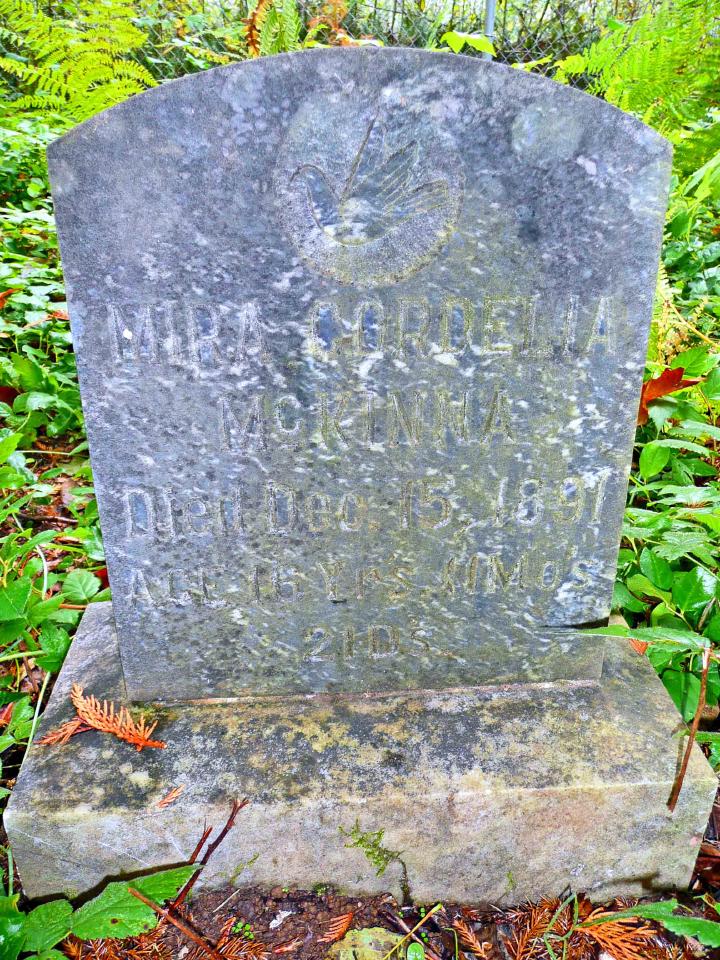
"Mira Cordelia |
[Update (Oct. 31, 2015): Stefanie Layson spotted a third marker in the Windom Cemetery. The only inscription on this marker are the initials "MB".]
Location of cemetery:
Topozone map - the "x" halfway up and a little right of center marks the cemetery.
The UTM coordinates are 10T 0527665 5139726
Lat/Long coordinates are 46° 24' 45" N 122° 38' 24" W
If you go to Google Earth for a satellite view, you can actually see the cemetery as a little clearing in the woods. In fact, you can actually detect the little tree in between the two stones if you have a good imagination! You can also see the road network of the old town, and its extent which shows up as different vegetation. It could be that the area is just one or two of the farms in the town of Windom which may have been further north on Cedar Creek, up what is now Cuts Road. I have a map that shows a "Windom Mine" at approximately the intersection of Cedar Creek Road and Cuts Road.
The only (approved) way it can be accessed by the public is through Weyerhaeuser's 19-mile network which they have open during hunting seasons. One drives through the 1901 gate, takes an immediate left on the 1909, then left on the 1940 which loops around and joins the main 1900. Follow the 1900 to the "To Cuts Road" sign and take that cutoff. After a mile or so, Cuts Road will go to the right, but it is closed. Take left on an 18-mile road and drive south for a couple miles...and that's where I need my Weyerhaeuser map to give numbers. If someone reviews the Google Earth satellite map or has a GPS, it will be easy to find, however.
Genealogical Information:
I did a little research on the Withrow family (couldn't find anything on McKinna). Sarah's father was James P. Withrow, b. abt 1851 in Georgia. Her mother was Melissa Ann Fore, b. abt 1850 in North Carolina. Sarah's sister, Alice, b. abt 1893 after Sarah had died, married Horace Greeley Hinkley, d. 23 Apr 1970 in Castle Rock. Alice d. 20 Oct 1970, also in Castle Rock. Sarah's brother, Johnathan (sic) b. 19 Feb 1886, d. Dec 1970 in Cosmopolis. Her brother Lester, b. abt 1998, d. 1973 in Toledo, married Annabelle Marie Simmerman. They had a daughter, Hazel Elene Withrow, b. 20 Jul 1915, probably deceased by now. From the 1910 census, you can see Sarah had other siblings: Andrew L., b. abt 1889; Mary, b. abt 1895; and Ettie, b. abt 1904. Ettie was still living with her parents in 1930.