Martin Island
For more information, see the listing for Martin Island in Meany's "Origin of Washington Place Names".
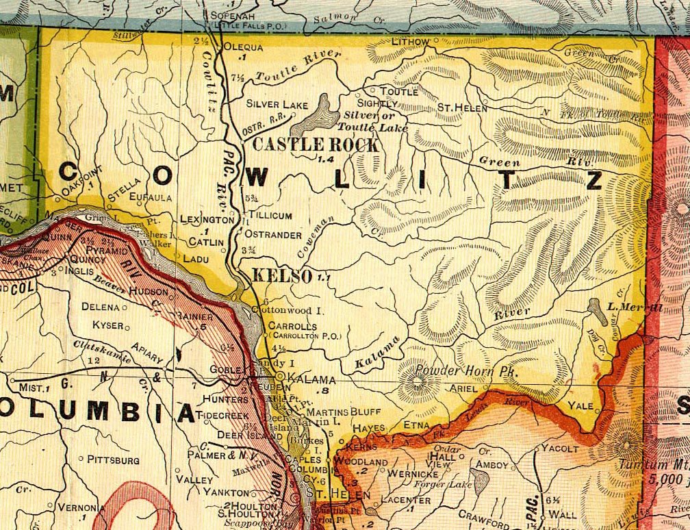
Martins Bluff
Martins Bluff was located about four miles southeast of Kalama on the Columbia River. It was named for William H. Martin, who established a post office which operated here from 1868 to 1916 (Ramsey, p. 166).
Martins Bluff Links:
Marysville
See under Catlin.
Merwin
Merwin, located near Lake Merwin along State Route 504, was named for L. T. Merwin of the Northwestern Electric Company, builders of Lake Merwin.
Mineral
Monticello
Monticello, now extinct, was located along the Columbia River at the present site of Longview. It was the first established town in the county, originally named Mount Solo. Harry Darby Huntington renamed the town in 1852 for his home town in Indiana. Jonathan Burbee and Harry Huntington were the first American settlers in this region, arriving in 1849 at the end of the reign of the Hudson Bay Company. The post office was established on November 28, 1850 by David Stone. For many years the Huntington family served as postmasters, as did Seth Catlin, Asa Harper and Royal C. Smith. Harry Huntington was born Sept. 12, 1811 in Monroe Co., NY and died Aug. 28, 1882. His brother Chandler Robinson Huntington was born July 29, 1817 at Ontario, NY and died Jan. 23, 1901. Harry's son Edwin was also a postmaster. From 1854 to 1865, Monticello was the county seat. However, Monticello lost the seat to Freeport in 1865 when the town could not provide any regular meeting space for the county commissioners (Summers, p. 233-34). Monticello was flooded on Dec. 17, 1867 by melting snow from Mt. Rainier. While no lives were lost, many residents abandoned the town for higher ground. Harry Darby Huntington rebuilt several businesses and homes in Monticello, but the town never regained its former status as a commercial center (Summers, p. 235-37). Once a strategic site for north-south river navigation, it was largely abandoned when the Northern Pacific built a railway at Kalama in 1872. The post office was discontinued in 1876, and by 1884, the Columbia River had once again flooded the original townsite (Ramsey, p. 149-154; Hunt and Kaylor, p. 446).
Monticello links:
- View the list of signers of the Monticello Convention
- 1940 Census Index, Monticello Precinct
- For more information, see the listing for Monticello in Meany's "Origin of Washington Place Names".
- See the entry for Monticello in the "Oregon, Washington and Alaska Gazetteer and Business Directory, 1901-1902"
Mount Coffin
See under LaDu.
Mount Coffin Links:
- For more information, see the listing for Mount Coffin in Meany's "Origin of Washington Place Names".
- See the entry for Mount Coffin in the "Oregon, Washington and Alaska Gazetteer and Business Directory, 1901-1902"
- Lyn Topinka has a great collection of photos and history of Mount Coffin as part of her "Columbia River Images" website.
Mount Solo
See under Monticello.
Oak Point
Oak Point is a small community located 14 miles west of Longview, near Stella, along the northern banks of the Columbia River. The post office was established by Alexander S. Abernathy on Feb. 18, 1851. The town was named for the very large oak trees, up to 13 feet around, which grew there. Alexander Abernathy owned a sawmill there, which he built in 1848. With his brother, George, he also built a grist mill. The post office was discontinued in 1937 (Ramsey, p. 154-55).
In his "Pioneer Days of Oregon History" [Vol. 1. Portland, OR: J. K. Gill Company, 1905. pp. 39-40], S. A. Clarke provides an account of how Oak Point got its name:
CHAPTER VIII: OAK POINT SETTLEMENT
"The first attempt to settle the Columbia was projected in 1809 by Abiel Winship, in his Boston counting house. As result, Captain Nathan Winship made a voyage to this river in the ship Albatross, for the purpose of building a two-story log house, that should serve for fort as a well as warehouse, and to cultivate land close by, using all needful precaution to preserve peace with the Indians. Mr. Winship of Boston wrote the instructions much as Astor did - to buy land of the natives and recognize their rights; thereafter to puruse a course that would be honorable and, it was hoped, insure peace, good will and prosperity. At the Sandwich Islands they took on board swine, goats and some Kanakas to work, and entered the Columbia May 26, 1810 - the first settlement ever projected in Oregon.
Captain Winship went forty miles up the river and selected a beautiful location were oak trees were grouped near the bank, therefore called it Oak Point, and that name it bears to-day - the only vestige that remains of that venture. He said it was the first point where oak trees were to be seen near the river. They commenced work, hewed timber and were making progress, when the June floods warned them that the site was too low; also, the Indians told them that the freshets always covered the locality. For this reason, and because the Indians became troublesome, and what they saw and heard led them to believe that the Chinooks only waited for a favorable occasion to capture them all, they concluded not to build, as was intended, but to trade along the coast awhile and leave for future decision the question of building the fort.
Franchére mentions seeing hewn timbers on the bank there. The ship tradedfor a year, and then Captain Winship saw the arrive of the Tonquin with the Astor company, and did not like to commence opposition to so well-equipped an enterprise."
Oak Point Links:
- For more information, see the listing for Oak Point in Meany's "Origin of Washington Place Names".
- See the entry for Oak Point in the "Oregon, Washington and Alaska Gazetteer and Business Directory, 1901-1902"
- Oak Point Cemetery (transcribed by Stephen S. Whitney
- Oak Point Cemetery (part of Interment.net Cemetery Transcription Library)
- 1910 Census Extraction for Oak Point precinct
- 1920 Census Extraction for Oak Point precinct
- 1930 Census Extraction for Oak Point precinct
- Archelaus F. "Keel" Low and Oak Point Piling and Lumber Co. (1914)
- Oak Point Piling and Lumber Company (1917)
Olequa
Olequa was located on Olequa Creek, 6 miles north of Castle Rock and near the former site of Pumphrey's Landing. It was also known as West Olequa. General John W. Spraque named the town for an Indian chief, Old Laquash, who lived in the area. The town was platted in 1872, after the railroad station was established. Samuel Davidson Laughlin established the post office which operated here from 1875 to 1912. Laughlin was born in Linn, Missouri on May 28, 1843, and came to the Washington Territory in 1873. While he was postmaster, the post office was based in his living room. George and Mary Bertrand, postmasters until the office was discontinued in 1912, ran a store in Olequa until 1950 (Ramsey, p. 175).
"One other old town, West Olequa, was platted the following year (1890) by William and Lizzie Pumphrey, pioneers in that section. The town was called West Olequa because of its location west of the Cowlitz River, but the railway station and post office there were always known as Olequa. Like Kalama it was named in 1871 by J. W. Sprague, President of the Northern Pacific Railroad. The exact origin of the word Olequa is not nown, but according to Henry C. Sicade, an authority on Indian names, it may come from the Indian word 'Ca-met-ze,' which means 'where the salmon runs to, or comes to.' The plat of Olequa was ordered vacated by the commissioners on April 19, 1927" (Cowlitz County Inventory, p. 14).
Olequa Links:
- 1940 Census Index, Olequa Precinct
- For more information, see the listing for Olequa in Meany's "Origin of Washington Place Names".
- See the entry for Olequa in the "Oregon, Washington and Alaska Gazetteer and Business Directory, 1901-1902"
Oloqua
William Pumphrey established a post office here which operated for one year, from Oct. 30, 1867 to July 16, 1868. It was probably the forerunner of Olequa and Pumphrey's Landing (Ramsey, p. 163).
Ostrander
Ostrander is located 3 miles northeast of Longview, just east of Interstate-5. It was once a sawmill town, housing the Ostrander Timber Company, with mill, store, and office. The post office was established in 1894 by Oliver Byerly, and operated out of the company store. The Northern Pacific Railway Company named the town in 1898 in honor of Dr. Nathaniel and Mrs. Eliza (Yates) Ostrander , who filed a Donation Land Claim there in 1852. Nathaniel Ostrander died in Olympia on Feb. 7, 1902, and Eliza Ostrander died Feb. 22, 1899. The post office was discontinued in 1939 (Ramsey, p. 195-6).
Ostrander Links:
- For more information, see the listing for Ostrander in Meany's "Origin of Washington Place Names".
- See the entry for Ostrander in the "Oregon, Washington and Alaska Gazetteer and Business Directory, 1901-1902"
- See the entry for Ostrander in Robert A. Reid's 1912 book, "Puget Sound and Western Washington."
- Ostrander and Kelso Mystery People - photos of friends and neighbors of the STOVER family of Ostrander. Can you identify any of these people?
- 1958 reunion of Ostrander School alumni from the class of 1893-1894 - can you identify these students?
Owl Creek
See under Rose Valley.
Owl Creek Links:
Pekin
Pekin was located about three miles south of Woodland, on the north bank of the Lewis River. The Pekin post office was established in 1854 by Jefferson Huff. Huff was born in Indiana and served as the county's first Representative to the Washington Territory legislature. The post office was discontinued in 1886 (Ramsey, p. 156-58).
Pekin Links:
- See the entry for Pekin in the "Oregon, Washington and Alaska Gazetteer and Business Directory, 1901-1902"
Pigeon Springs
Located in central Cowlitz County, about 10 miles northeast of Kalama, near one of the tributaries to the Kalama River.
Pigeon Springs Links:
Pleasant Hill I
See under Tucker.
Pleasant Hill II
Was located about half-way between Kelso and Longview. No further information available.
Plomondon Island
See under Fisher Island.
Puolongan Hill
See under Columbia Heights.
Pumphrey's Landing
Pumphrey's Landing was located near the old site of Oloqua, on the west bank of the Cowlitz River, about 8 miles north of Castle Rock. William Pumphrey established Pumphrey's Landing as a continuation of the Oloqua post office, and operated a post office here from 1870 to 1874 (Ramsey, p. 169).
Reno
Reno was located along State Route 503 between Woodland and Ariel. A post office operated here from 1912 to 1919, with Mrs. Effie Elizabeth (Newkirk) Axtell as postmaster (wife of John C. Axtell) (Ramsey, p. 204). In the 1940 census, the Reno Election Precinct included the communities of Ariel and Clover Valley.
Reno Links:
Rose Valley
Formerly known as Goble Creek, Shanghai, and Owl Creek. The following information was submitted by Rita K. Cobb Balch: "My mom's family (the Parson's) have been out in Rose Valley for ages... I don't know if they ever had a post office... but it is a growing community... It has the school, a store with a gas station (I remember when there were 2 stores), the Friends Church, the cemetery, a fire station, the grange (that Parsons family have been involved in forever it seems)... beside the grange is a small garage that used to be the school bus garage before Rose Valley was incorporated into the Kelso School District. My grandma, Dot Parsons was head cook at Rose Valley School for 17 years, until it was incorporated into the Kelso School District. I know further out near the Coweeman, there was an old school house... I lived in the teachers cottage when I was a little girl before my parents bought their home in Castle Rock in October 1964. There is also the Melody Ranch..."
On the origins of the name Shanghai, the "History of Cowlitz County, Washington," gives the following account: "About two miles farther on (from Rose Valley) in the district known as Shanghai, John Choate settled about 1865. When he was asked how the name happended to be given he said that he had used it in the spirit of fun and that the name stuck. Another old resident related that some of the first pioneers had brought with them a crate of Shanghai chickens and while making camp the box fell from the wagon and was broken, poultry escaping into the wilds." (Ott and York, p. 123)
Early pioneers in Rose Valley included: James S. Huntington, W. O. Huntington, Samuel Adams, Tom Reece, L. D. Carpenter, John Goggs, John Lysons. Tom Reece married Delia Huntington, daughter of Dan Huntington. (Ott and York, p. 123)
Rose Valley Links:
- 1880 Census for Owl Creek Precinct, Cowlitz Co.
- For more information, see the listing for Shanghai Valley in Meany's "Origin of Washington Place Names".
Ryderwood
Ryderwood is located on Campbell Creek, one mile south of the Lewis-Cowlitz county line, at the terminus of State Route 506 (the townsite was formed from part of Cougar Flat precinct). It was formerly a logging town for the Long-Bell Lumber Company, and began construction in 1923. The company named the town in honor of W. F. Ryder, a 35-year employee of the company. At its peak, there were 2000 residents, 1100 of them on the lumber company's payroll. In 1952, the town was sold to a real estate company, who redeveloped the area as a retirement community. Today, many of the town's 300 residents are retirees (Erickson, p. 83-5).
Ryderwood links:
- More information about the sale of Ryderwood - 1953 article published in "The Daily Chronicle"
- "A Town for Old Folks" - article published in the September 1955 issue of The Rotarian.
- "Geezer fire brigade protects West's first retirement community"
Saint Helens
Saint Helens is located in the Toutle River Valley, 13 miles northeast of Toutle. The post office was established in 1892 as Sugar Creek, one mile northeast of the present-day townsite. Samuel Crum was the first postmaster, serving 50 patrons in 1893. The town was renamed Saint Helens, for nearby Mt. St. Helens, in October, 1893 (Ramsey, p. 194-95)
Saint Helens links:
- For more information, see the listing for Saint Helens in Meany's "Origin of Washington Place Names".
- See the entry for St Helens in the "Oregon, Washington and Alaska Gazetteer and Business Directory, 1901-1902"
- Two views of Mt. St. Helens (before the eruption) - View 1 and View 2
- Perry Brake's website - with information on the Toutle River valley and Mount Saint Helens, including his family home in Saint Helens.
Sandy Bend
Located near Castle Rock. The first donation land claim was made by Dan Little, Jacob Huntington, Norman Burbee and Commodore Moore. Mills provide most of the employment. Sandy Bend School built in about 1880 but was consolidated with Castle Rock School District in 1952 (Ott and York, p. 128).
Shanghai
See under Rose Valley.
Sightly
Sightly was located 8 miles east of Silverlake, near the old Toutle post office. When settlers planned to establish a school and post office, they chose the name Sightly because of the view of Mt. St. Helens. Alexander Lewis was the first postmaster in 1884, and ran the post office from his home. The post office continued to run from the homes of subsequent postmasters, including Marquis De L. Cunningham and Joseph Henry and Margaret (Glennon) Hallock, until 1913 (Ramsey, p. 182).
Silver Lake
Silver Lake is located 7 miles east of Interstate-5 on State Route 504, and the north end of Silver Lake, its namesake. The earliest settlers here were George White and James Farnsworth, who established donation land claims in 1870. Hiram Germond soon followed, and by the fall of 1870 they were joined by several other families, including David Germond, C. Corothers, Jacob Tippery, Charles Seaquest, P.H. Farnsworth, A. Bullock, William Morrell, William Dahlman, Andy Dalquist, and Patrick Flynn (Ott and York, p. 130). Mrs. Drusilla Germond was the first postmaster, from April 1, 1875 to April 5, 1876 (Ramsey, p. 172-4). Silver Lake is a popular tourist spot, with the lake and several Mt. St. Helens Visitors' Centers the main attractions.
Silver Lake Links:
- For more information, see the listing for Silver Lake in Meany's "Origin of Washington Place Names".
- Silver Lake Cemetery - transcribed by Linda Smith.
Spillel
See under Yale.
Stella
Stella is located on State Route 4, 12 miles west of Kelso, on the north bank of the Columbia River. John A. Packard, a local storekeeper and trader, was also the first postmaster in 1884, naming the town for his daughter. The post office was discontinued in 1935. The economy of Stella relied heavily on lumbering and the dairy industry for many years (Ramsey, 182-3).
Stella Links:
- For more information, see the listing for Stella in Meany's "Origin of Washington Place Names".
- See the entry for Stella in the "Oregon, Washington and Alaska Gazetteer and Business Directory, 1901-1902"
- Lyn Topinka has a great collection of photos and history of Stella as part of her "Columbia River Images" website.
Stockport
See under Tucker.
Sugar Creek
See under Saint Helens.
Tillicum
This town is not listed in Guy Ramsey's book, but does appear on a Cram's 1909 map of Cowlitz County. It is located just north of Ostrander.
Toutle
The current site of Toutle is located 4 miles east of Silverlake on State Route 504. The site of the original townsite is unknown, but was located near the south fork of the Toutle River. In 1841, Toutle's name was derived from Hullooetell, a local Indian tribe name. Napoleon Gardner established the post office in 1883. His sons William F. Garder (who married Eliza May Bemis) and Harry Gardner were also postmasters. The townsite was moved in Feb. 1950 (Ramsey, p. 180).
Toutle Links:
- For more information, see the listing for Toutle in Meany's "Origin of Washington Place Names".
- See the entry for Toutle in the "Oregon, Washington and Alaska Gazetteer and Business Directory, 1901-1902"
- Mt. St. Helens Communities - Toutle - by Cowlitz County Tourism
Tower
The Towers homestead was located on the north bank of the Toutle River, 12 miles northeast of Castle Rock. James Wilkinson bought the homestead and established a post office there in 1886. The post office was discontinued in 1927 (Ramsey, p. 184-87).
Tower Links:
- See the entry for Tower in the "Oregon, Washington and Alaska Gazetteer and Business Directory, 1901-1902"
Tucker
Tucker was a railroad station located 3 miles south of Castle Rock, and was also known as Stockport and Pleasant Hill. The Northern Pacific Railway Company named the town in 1888 after a settler for whom the railway acquired right-of-way. Noyes Henry Smith established the post office here in 1884. Smith was born in Hanover, Illinois on October 25, 1823. He married Hannah Jane Huntington, daughter of Jacob and Susan Huntington, in Monticello in 1865. His sister, Arabella Smith, married Chandler Robinson Huntington, brother of Harry Darby Huntington. Noyes Smith died Feb. 6, 1899. The post office was discontinued in 1905 (Ramsey, p. 184).
Tucker Links:
- See the entry for Tucker in the "Oregon, Washington and Alaska Gazetteer and Business Directory, 1901-1902"
Upper Coweeman
A precinct in the 1930 and 1940 censuses. From the information provided in the census, Upper Coweeman was located either within or close to Longview city limits.
Upper Coweeman Links:
West Kelso
See under Catlin.
Woodland
[2000 population: 3,780 (3,688 in Cowlitz Co. and 92 in Clark Co.)] Woodland is located 19 miles south of Kelso, west of Interstate-5 along the Cowlitz-Clark Co. border. The townsite was located on a Donation Land Claim owned by Christopher C. Bozarth, who established the post office here in 1882. His step-daughter's husband, Samuel Conrad, was postmaster. For one month in 1890, this post office was named Kerns (Ramsey, p. 176-80).
Woodland Links:
- 1940 Census Index, Woodland, North Precinct
- See the entry for Woodland in the "Oregon, Washington and Alaska Gazetteer and Business Directory, 1901-1902"
- "Water Babies" - Margaret Hepola's history of the North Fork valley of the Lewis River before it was flooded by the creation of the Merwin Dam.
- "...Fields of Flowers and Forests of Firs...A History of the Woodland Community 1850-1958." - Judy Card's 1999 Revision of this history of the pioneers of Woodland.
- Historic Homes of Woodland - written by Melinda Talley. Historical background on the Guild-Kladys families also given.
- History of Woodland - brief history of Woodland, posted on the Lewis River Valley website.
- "Lewis River News" - extracts of obituaries and other items of genealogical interest from this Woodland-area newspaper.
- Woodland I. O. O. F. Cemetery transcription
- Green Mountain School District #103
- Woodland School District
- Woodland Chamber of Commerce
- Lyn Topinka has a great collection of photos and history Lewis River, including its bridge.
- Mt. St. Helens Communities - Woodland - by Cowlitz County Tourism
- View photos of Woodland area families
Yale
Yale was located at the east end of Lake Merwin, off of State Route 503, between Ariel and Cougar. It was originally named Spillel, after Spillel Creek (E. Meany calls this Spilyeh Creek). The post office was established in 1898 by Mary C. Smith (who married Augustus Smith). The post office was located in her home, which burned down in the Yacolt forest fire of 1902. The post office was discontinued in 1940, and the original townsite is now flooded by the Yale Dam (Ramsey, p. 198).
Yale Links:
- For more information, see the listing for Yale in Meany's "Origin of Washington Place Names".
- See the entry for Yale in the "Oregon, Washington and Alaska Gazetteer and Business Directory, 1901-1902"
- "Clark and Cowlitz counties erect Yale Bridge across Lewis River in 1932" - an article written by Priscilla Long for HistoryLink.org.